Description:
Prime farmland soils are
utilized for food production and overall health of our environment and are
being affected due to the process of urbanization. This application is
representing the total area of farmland that has been lost due to impervious
features, such as paved parking lots in the town Easton, Massachusetts. The
overall goal of the project is to calculate the total loss of farmland due to
development within Easton.
Process:
To
begin this process the team created a map representing our study area, which is
the town of Easton, Massachusetts. We then added the soils data which contains
the three farmland categories (prime farmland, farmland of statewide
importance, and farmland of unique importance) that we would be collecting
information for. To do this, we separated the cells that represented the town
of Easton and combined them to the soil data. The team then combined an
additional subset to the map which contained the data representing impervious
areas. To do this we had to separate the cells representing our study area. We
then combined the amount of farmland lost for each of the farmland categories.
Before we can combine them, we had to create a new field within the table of
attributes to make it work properly. In order to collect the statistics of the amount of area farmland
lost within the three farmland categories we repeated the process of viewing
the statistics given by the table of attributes.
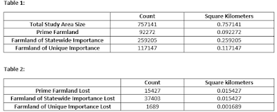
Results: The data collected for our study area represents the total study area size, the amount of farmland, farmland of statewide importance, farmland of unique importance, as well as all three of these categories in comparison to the amount of farmland lost within them. The total area size of the town of Easton equals to be .75 square kilometers. Refer to Table 1 and Table 2 for results.
Conclusions:
Maggie Payne, a resource soil scientist
presented information that made this study easier to comprehend. She explained
the importance of why each of these farmland categories which highlighted the
importance of the entire study. There was not many limitations to the study or
the process of data collection, but one thing that may make the study more
effective is knowing what makes an area impervious. Right now, all that we know
is that there is impervious areas that resulted in loss of farmland but we do
not know what that impervious land is. I also think that having a timeline of
when the land was taken would be interesting because then researchers could
look further into if there were efforts to stop the land from being taken.


No comments:
Post a Comment