http://arcg.is/2lwLMFZ
Description
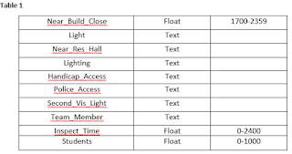
The purpose of this application is to illustrate the locations of the Blue Light locations across the Bridgewater State University (BSU) campus. Each point has data collected demonstrating the accessibility and overall safety of the light. The data collected also represents the safety in regards to the surrounding buildings, population, and general visibility (see Table 1).
Process The first step in the process was choosing the focus of the project, in this case it was the Blue Lights on the BSU campus. We created the map with the online ArcGIS program, putting down a base map of streets and zoomed into the BSU area. We used the BSU official published campus map to then add points onto our map – the points represent the locations of the blue lights across the campus. After implementing all of the points we went out in the field to collect data information at nine of the many locations, using the Collector app. We then went back into the online program to ensure all the data was implemented correctly and changed the symbology to represent the points we gathered data for.
Conclusion
While completing this project there were a few difficulties that we ran into. Before going out in the field to collect data, we added all of the points to our map based off of the Bridgewater State University Campus Map published on their website. When we went out to the field we realized that we could not input data into these points on the collector app. We had to create new points and then go back into the web application and remove the old, inaccurate ones.
Another thing I learned is not in reference to the application itself, but in regards to the overall project. Because we were basing our original points off the
University’s published map we were sure that all of our points would be
accurate. Unfortunately we learned that there are points on our campus map
showing a Blue Light, yet out in the field there was not one. This is important
to highlight because we now know that if although something may have been
published and approved, there could have been altercations that make that map
inaccurate demonstrating that adding the points before going to collect data
made this process harder.

No comments:
Post a Comment